This post is part of a special three-part series about hail. Part 1 starts the series by discussing what hail is and where it comes from.
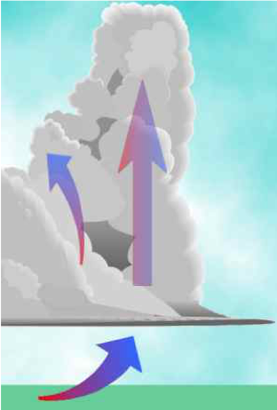
Hail is frozen precipitation, born of the updrafts of thunderstorms. Updrafts are rising air currents, which combined with cold temperatures and water droplets, are the primary forces that create hail. Such conditions are frequently present in the middle and upper portions of thunderstorms.
Hailstone embryos form inside storm clouds on small frozen raindrops and on “snow pellets” called graupel. They grow into true hailstones by accumulating ice through a process called accretion, by capturing supercooled (below 0 °C) water droplets in cloud regions with temperatures below the freezing point, 0 °C (32 °F). Hailstones sometimes contain pebbles, leaves, twigs, nuts, and insects that have been lofted into the clouds by strong updraft winds.
For the hail embryos to grow, they must remain in a layer of supercooled water for a length of time — the longer they stay there, the larger the size. They are kept in this layer by strong updrafts that construct the great towers of the cumulonimbus (Cb) clouds. The updrafts push the Cb cloud tops high into the atmosphere, creating the environment for lightning, thunder, and the various wind characteristics of thunderstorms.
Rising air (updraft) of at least 60 km/h (40 mph) is required to form dime-size hail. Golf-ball size stones (4.5 cm diameter) form when updrafts reach approximately 100 km/h (60 mph), and softball-size hail forms inside updrafts reaching 160 km/h (100 mph; NWS). To form hailstones the size of golf balls, over ten billion supercooled droplets must be accumulated, and thus the hailstone must remain in the storm cloud for at least 5 to 10 minutes. Once a hailstone has reached a weight which the updraft can no longer support, it falls to the ground.
Hailstones form in onion-like layers of opaque and clear ice. Clear layers form when colliding water droplets freeze slowly in cloud layers that are slightly below freezing, allowing air bubbles to escape. This process is termed “wet growth”. Opaque layers, with a “milky” texture, form when colliding water droplets freeze rapidly in cloud layers that are well-below freezing. The rapidity of the freezing prevents air bubbles from escaping. This process is termed “dry growth”.
When hailstones collide inside the thunderstorm, they may break into smaller pieces or become welded together into larger irregular shapes. Large hailstones can fall at a maximum speed of 170 km/h (105 mph).
Hailstones don’t have to travel up and down in a thunderstorm cloud however. Sometimes they drift slowly downward through the storm, accumulating water droplets and growing as they pass through supercooled water layers. These stones will have a more uniform structure, rather than layered.
Not all hailstones survive that downward trip. Forty to seventy percent of the hailstones that form within a thunderstorm cloud melt before reaching the ground.
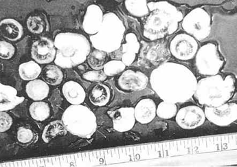
A series of descriptor terms are used to communicate the size of hailstones, ranging from pea-sized to softball-sized. The best way to report the size of a hailstone is to measure it with a ruler or to compare it with a commonly-known object that does not vary in size, such as a coin. Marbles, although often used as a descriptor, is not a great object to compare to due to the varying sizes of marbles.
One of the largest hailstones ever documented occurred on July 23, 2010 in South Dakota. The hailstone had a diameter of 8-inches, or about 20 cm (NWS). Jim Scarlett, meteorologist in charge at the National Weather Service in Aberdeen, SD remarked “I described this one as cantaloupe-size.” The July 23 storm sent hailstones that broke through roofs, leaving fist-size holes in interior ceilings, smashing through windshields and causing at least five injuries to stranded motorists on I-90. Dents in the ground were still visible the following day.
Weatherlogics predicts the locations of future hail storms and collects data on hail events. This information is critical to ensure we have an accurate understanding of hail risk. For more information about these services, click here.
In our next article in this series on hail, we’ll be discussing the characteristics of hailstones, storm patterns associated with hail, and weather forecasting and hail damage assessments.